Avancerade geofysiska tjänster för komplext beslutsfattande
Vi är specialiserade på geofysiska tjänster för olika branscher, inklusive infrastruktur, vatten & avlopp, energi & allmännytta samt offentlig sektor.
Några av våra 300+ kunder
✔ Med 40+ år i branschen, 300+ kunder och 1000+ projekt sedan vi grundades på 80-talet, kan vi leverera gedigen erfarenhet och exceptionell kvalitet.
Fördelar med vår metodik
Vår metodik erbjuder en rad fördelar, inklusive förbättrad resursutforskning, optimerade produktionsprocesser och förbättrad supply chain management.
Minskar kostnaderna
Geofysiska undersökningar är ett effektivt, så kallat oförstörande sätt att minska projektkostnaderna.
Förhindra större skador
En undersökning ger dig kritisk information för att förhindra skador, t.ex. vattenläckor eller korrosion.
Lönsamma insikter
En undersökning ger er insikter och möjligheter att hitta mer lönsamma arbetssätt framöver.
Våra tjänster
Våra geofysiska tjänster använder avancerad teknik och utrustning för att tillhandahålla korrekta och tillförlitliga data om underjordiska strukturer och funktioner. Vi erbjuder skräddarsydda lösningar och arbetar nära våra kunder för att möta deras specifika behov.
Industri
GPR kan användas i industriområden för att kontrollera och övervaka sättningar i mark eller andra strukturer. Den kan också användas för att lokalisera försämring av byggmaterial. Väggar och strukturer kan också kontrolleras och övervakas.
Infrastruktur
GPR är en utmärkt och väl beprövad metod, för att både lokalisera rätt plats för ny infrastruktur och kontrollera befintlig. Den används över hela världen för tunnlar, vägar, motorvägar, broar, viadukter och för kanaler och energianläggningar.
Rörledningar
GPR används oftast med andra verktyg för att markera specifika områden av komplexa ledningsnät och markstrukturer. Det är den enda metoden som kan lokalisera och kartlägga allt material, t.ex. PVC, PE, gråjärn och betong.
Byggnadsunderhåll
GPR är en väl fungerande oförstörande metod för kontroll och restaurering av historiska byggnader och monument. Adapis har lång erfarenhet av studier om historiska parker, trädgårdar och kontroll av historiska träddelar.
Forensik
Vi kan bistå med "Search and Rescue" av försvunna personer samt utredning och lokalisering av förmodade avlidna personer. Processen liknar arkeologins. GPR används med en magnetometer, stångslingram och metalldetektor.
Förorening
GPR kan lokalisera och avgränsa förorenade områden och underjordiska depåer. Med karakterisering av sediment gör vi en bedömning av riskområden. Den används också för att lokalisera läckor från tankar eller rörledningar.
Arkeologi
Vi upptäcker, lokaliserar och kartlägger nedgrävda historiska och förhistoriska byggnader, strukturer och föremål. Vi arbetar även med kartläggning och stratigrafiska sektioner av vallgravar, gravhögar, fästningar och stenplatser.
Markförhållanden
GPR kan användas för att analysera markförhållanden på en bergyta. Den är lämplig för kartläggning av lagersekvenser, djup i berg och identifiering av svaga zoner i berg. Styrkan och placeringen av lera, jord, block och stenar kan bestämmas.
Genomförda projekt
BRANSCHERFARENHET
NÖJDA KUNDER
Vanliga frågor
Här hittar du svar på vanliga frågor om vad Georadar är (även "Ground Radar"), hur det fungerar och hur man lokaliserar, kartlägger och undersöker objekt med en Georadar.
Vad är en Georadar och hur fungerar den?
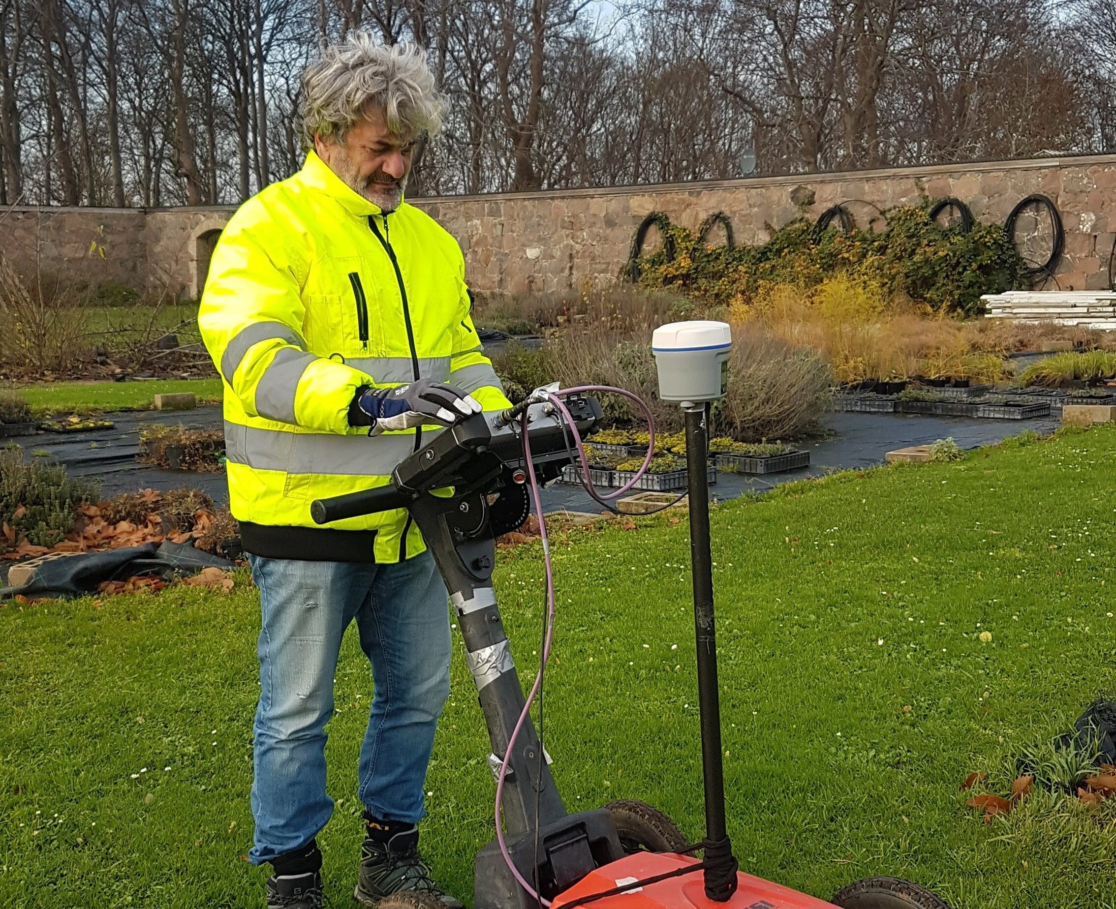
Georadar, även känd som markpenetrerande radar (GPR), är en geofysisk avbildningsteknik som använder radarpulser för att avbilda jordens underyta. GPR-utrustning består av en styrenhet, en sändande antenn och en mottagningsantenn. Sändningsantennen sänder ut högfrekventa elektromagnetiska vågor, typiskt i intervallet 10-1000 MHz, i marken. Dessa vågor penetrerar marken och interagerar med underjordiska material, såsom stenar, jord och begravda föremål. Mottagningsantennen detekterar sedan de reflekterade vågorna som studsar tillbaka till ytan, och denna data används för att skapa en underjordisk bild.
Vilka är fördelarna med Georadar för undersökningar under marken?
Det finns flera fördelar med att använda georadar för undersökningar, inklusive:
1. Icke-invasiv: Georadar är en icke-förstörande och icke-invasiv teknik som möjliggör undersökningar under ytan utan behov av borrning eller schaktning.
2. Högupplöst avbildning: Georadar kan tillhandahålla högupplöst avbildning av underjordiska strukturer och funktioner, vilket möjliggör detaljerad kartläggning av geologiska och miljömässiga förhållanden.
3. Snabbt och effektivt: Georadar kan snabbt och effektivt kartlägga stora områden, vilket minskar tiden och kostnaderna för undersökningar under marken.
4. Mångsidig: Georadar kan användas i ett brett spektrum av tillämpningar, såsom arkeologiska undersökningar, miljöstudier, ingenjörsprojekt och geologisk kartläggning.
5. Säker: Georadar är en säker och lågriskteknik som inte använder joniserande strålning eller andra farliga material.
6. Exakt: Georadar kan tillhandahålla korrekta och tillförlitliga data under ytan, vilket kan hjälpa till att fatta välgrundade beslut inom olika områden.
Sammantaget är georadar ett värdefullt verktyg för undersökningar under marken som kan ge viktig information för ett brett spektrum av applikationer, samtidigt som det minskar kostnaderna och minimerar miljöpåverkan.
What types of applications is georadar commonly used for?
Georadar används ofta i ett brett spektrum av applikationer, inklusive:
1. Arkeologi: Georadar används för att lokalisera och kartlägga nedgrävda strukturer, artefakter och andra funktioner på arkeologiska platser.
2. Miljövetenskap: Georadar används för att undersöka förhållanden under ytan för studier av grundvattenföroreningar, kartläggning av markfuktighet och övervakning av deponier.
3. Anläggningsteknik: Georadar används för geotekniska undersökningar, såsom kartläggning av berg och jordlager under ytan, lokalisering av nedgrävda verktyg och bedömning av betong- och asfaltbeläggningsförhållanden.
4. Gruvdrift: Georadar används för att kartlägga geologiska strukturer, upptäcka förkastningar och lokalisera mineralfyndigheter.
5. Geologi: Georadar används för att undersöka geologiska formationer och strukturer under ytan, inklusive förkastningar, akviferer och berggrund.
6. Lokalisering av verktyg: Georadar används för att lokalisera nedgrävda kraftledningar och infrastruktur, såsom rör, kablar och underjordiska lagringstankar.
7. Konstruktion: Georadar används för bedömningar före konstruktion, som att identifiera potentiella sjunkhål eller tomrum och övervaka stabiliteten i utgrävningar och fundament.
Vilka är begränsningarna för georadar?
Även om georadar är en värdefull teknik för undersökningar under ytan, har den vissa begränsningar, inklusive:
1. Begränsat penetrationsdjup: Genomträngningsdjupet för georadarvågor beror på typen av jord eller sten, radarsignalens frekvens och målets storlek. Generellt sett kan georadar penetrera upp till några meter under optimala förhållanden, men penetrationen är begränsad i täta eller ledande material.
2. Dålig upplösning under vissa förhållanden: Upplösningen för georadarbilder beror på radarsignalens frekvens, målets storlek och kontrasten i dielektriska egenskaper mellan målet och det omgivande materialet. I vissa fall, som i lera eller andra material med låg kontrast, kan upplösningen för georadarbilder vara begränsad.
3. Interferens från ytegenskaper: Georadarvågor kan påverkas av ytegenskaper, såsom vegetation, byggnader och ojämn terräng, vilket kan orsaka reflektioner och störningar i data.
4. Begränsad tolkning: Tolkning av georadardata kräver expertis och erfarenhet, och resultaten kanske inte alltid är avgörande eller definitiva. I vissa fall kan andra tekniker behövas för att bekräfta eller förfina resultaten.
Hur exakt är georadardata?
Noggrannheten hos georadardata beror på flera faktorer, inklusive typen av material som undersöks, penetrationsdjupet, radarsignalens upplösning och tolkningen av data. Generellt sett kan georadar tillhandahålla korrekta och tillförlitliga underjordiska data när de används på rätt sätt och tolkas av erfarna proffs.
Genomträngningsdjupet för georadarvågor beror på materialegenskaperna, såsom dess elektriska ledningsförmåga och dielektriska permittivitet, såväl som radarsignalens frekvens och effekt. Under optimala förhållanden kan georadar penetrera flera meter ner i underytan och ge detaljerade bilder av strukturerna och funktionerna inom det djupområdet.
Upplösningen för georadardata beror på radarsignalens frekvens, med högre frekvenser som ger högre upplösning men grundare penetration. Upplösningen kan också påverkas av målets storlek och form och kontrasten i dielektriska egenskaper mellan målet och det omgivande materialet.
Att tolka georadardata kräver expertis och erfarenhet inom området, samt förståelse för utredningens specifika förutsättningar. Tolkningen av data kan påverka resultatens noggrannhet, och i vissa fall kan andra tekniker behövas för att bekräfta eller förfina resultaten.
Vad är skillnaden mellan 2D och 3D underjordisk avbildning?
Skillnaden mellan 2D och 3D underjordisk avbildning är detaljnivån och komplexiteten i de resulterande bilderna.
2D-avbildning under ytan innebär insamling av data längs en tvådimensionell profil eller sektion, vanligtvis i ett enda plan. Detta kan vara användbart för att identifiera platsen, djupet och den ungefärliga storleken på underjordiska egenskaper, men ger kanske inte en fullständig bild av den övergripande strukturen. 2D-avbildning används ofta i georadarundersökningar för lokalisering av verktyg, betongskanning och andra applikationer där en enkel och snabb bedömning av underjordiska egenskaper krävs.
3D-avbildning under ytan innebär insamling av data längs flera profiler eller sektioner, vanligtvis i flera plan. Detta resulterar i en mer komplex och detaljerad bild av den underjordiska strukturen, vilket kan vara till hjälp för att identifiera formen, orienteringen och interna detaljer för funktioner som begravda föremål, geologiska formationer eller betongstrukturer. 3D-avbildning används ofta i georadarundersökningar för geologiska och gruvtillämpningar, såväl som för detaljerad analys av strukturer som broar, byggnader och dammar.
Generellt sett är 2D-avbildning snabbare och billigare än 3D-avbildning, men ger mindre detaljer och en mer begränsad bild av underjordsstrukturen. 3D-avbildning är mer komplex och tidskrävande, men kan ge en mer fullständig och korrekt bild av underytan, vilket gör det till ett värdefullt verktyg för mer djupgående undersökningar och detaljerad analys.
Vilka är säkerhetsaspekterna vid användning av georadar?
Georadar anses allmänt vara säker när den används på rätt sätt av utbildad personal. Det finns dock några potentiella säkerhetsproblem som bör beaktas när du använder georadar: Till exempel el-, miljö- och platssäkerhet. Sammantaget, även om georadar potentiellt kan utgöra vissa säkerhetsrisker om den inte används på rätt sätt, kan dessa risker minimeras genom korrekt utbildning, underhåll av utrustning och säkerhetsprotokoll. Med lämpliga säkerhetsåtgärder på plats anses georadar i allmänhet vara ett säkert och effektivt verktyg för undersökningar under markytan.
Hur väljer jag en leverantör av geofysiktjänster?
Att välja en leverantör av geofysiktjänster kräver noggrann övervägande av flera faktorer, inklusive projektets omfattning, leverantörens expertis och erfarenhet samt kostnaden och tidslinjen för projektet. Här är några faktorer att tänka på när du väljer en geofysiktjänstleverantör:
1. Expertis och erfarenhet: Leta efter en tjänsteleverantör med bevisad erfarenhet av framgång inom ditt specifika intresseområde, oavsett om det är geologisk kartläggning, miljöundersökningar eller strukturell avbildning. Kontrollera leverantörens referenser, certifieringar och recensioner från tidigare kunder för att säkerställa att de har nödvändig expertis och erfarenhet för att hantera ditt projekt.
2. Utbud av tjänster: Tänk på utbudet av tjänster som erbjuds av leverantören, såväl som deras förmåga att anpassa sina tjänster för att möta dina specifika behov. Vissa leverantörer kan specialisera sig på en viss typ av geofysiktjänster, medan andra kan erbjuda ett brett utbud av tjänster, inklusive georadar, seismiska undersökningar, magnetiska undersökningar och andra.
3. Utrustning och teknik: Leta efter en leverantör som använder den senaste utrustningen och tekniken för att säkerställa korrekta och pålitliga resultat. Fråga om leverantörens utrustningsunderhåll och kalibreringsprocedurer för att säkerställa att deras utrustning är i gott skick.
4. Kostnad och tidslinje: Tänk på kostnaden och tidslinjen för projektet och leta efter en leverantör som erbjuder konkurrenskraftiga priser och realistiska tidslinjer. Var försiktig med leverantörer som erbjuder ovanligt låga priser eller orealistiska handläggningstider, eftersom detta kan tyda på bristande erfarenhet eller kvalitet.
5. Kommunikation och samarbete: Välj en leverantör som värdesätter tydlig och effektiv kommunikation, och som är villig att samarbeta med dig för att säkerställa att dina projektmål uppfylls. Leta efter en leverantör som erbjuder regelbundna framstegsuppdateringar och som är lyhörd för dina frågor och funderingar.
Vilken information behöver jag ange i min offertförfrågan?
När du begär en offert är det viktigt att ge detaljerad information om ditt projekt för att säkerställa att vi kan ge en korrekt och heltäckande offert. Här är några viktiga delar av information som du bör inkludera i din offertförfrågan (RFQ):
1. Arbetets omfattning: Ge en detaljerad beskrivning av arbetets omfattning, inklusive vilken typ av geofysisk undersökning eller undersökning du behöver, det specifika området eller platsen som ska undersökas och alla andra relevanta detaljer.
2. Mål: Definiera tydligt målen för projektet och den specifika information du hoppas få genom den geofysiska undersökningen eller undersökningen.
3. Tidslinje: Ange en tidslinje för projektet, inklusive eventuella deadlines eller milstolpar som måste uppfyllas.
4. Budget: Ange ett budgetintervall för projektet, om möjligt, för att hjälpa oss förstå dina ekonomiska begränsningar och avgöra om vi kan uppfylla dina krav.
5. Platsåtkomst: Beskriv eventuella begränsningar eller krav på platsåtkomst som vi bör vara medvetna om, såsom behovet av säkerhetstillstånd eller särskilda tillstånd.
6. Leveranser: Ange de leveranser du förväntar dig av oss, såsom en detaljerad rapport, kartor eller andra typer av data eller analys.
7. Kvalitetskontroll: Ge information om eventuella kvalitetskontroller eller kvalitetssäkringskrav som måste uppfyllas som en del av projektet.
Genom att tillhandahålla detaljerad och heltäckande information om ditt projekt i din offertförfrågan kan du hjälpa till att säkerställa att vi kan tillhandahålla en korrekt och konkurrenskraftig offert som uppfyller dina behov.
Vad är priset för våra geofysiktjänster?
För att ge ett utförligt svar och ett citat behöver vi undersöka: (1) var undersökningen genomförs geografiskt (både vad gäller den fysiska parametern men också för att planera resor), (2) maximalt undersökningsdjup (att välja rätt verktyg), (3 ) hur stort det förväntade objektet är (samt om det är ett eller flera objekt). Offerten kan specificeras enligt flera prismodeller, inklusive (1) fakturering per kvadratmeter som ska undersökas, (2) per arbetstimme eller (3) projektpris, (4) och/eller utifrån andra kriterier, som du önskar . För att ge ett optimalt resultat ingår en detaljplanering med kravspecifikation, utförande, och bearbetning med analys.
Vill du veta mer?
Vi svarar gärna på frågor om våra tjänster och hur vi kan hjälpa dig. Här kan du också skicka din offertförfrågan (RFQ). Du kan även maila info@georadar.se eller ringa Roberto Grassi (Ägare), på 0706 - 12 31 20.
